Capital District and Kingston Launch Public Sewage Discharge Reporting
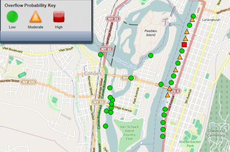
This map shows a portion of the Capital District sewage discharge notification system at albanypool.org, as it appeared on Dec. 23, 2014. Troy is to the right. Cohoes and Green Island are to the left.
View more images on our Flickr site
River lovers now have better access to realtime information about seven communities that discharge raw sewage to the Hudson River and its tributaries during rain. Six Capital District communities, and Kingston, have new web-based notification systems to alert the public when their combined sewer overflow (CSO) systems are discharging untreated sewage.
Exposure to untreated sewage is the primary cause of illness from recreational water use. Riverkeeper’s water quality sampling has found that contamination from sewage and other fecal sources is often worse after rain, in part because nearly 600 CSO outfalls discharge to the Hudson River estuary and other waters around New York City. Combined sewer systems were designed to carry both sewage and runoff from streets. When stormwater or snowmelt overwhelms the system, a mixture of raw sewage and polluted street runoff is discharged from points in the collection system so the high flows don’t overwhelm the treatment plants.
Six communities in the Capital District — Albany, Troy, Rensselaer, Cohoes, Watervliet and Green Island — launched a public reporting system at albanypool.org that uses a computer model to predict the likelihood of each of 92 CSO outfalls discharging to the Hudson and Mohawk Rivers, and their tributaries, in different rain scenarios. A simple map shows each outfall, with a different color-coded symbol indicating whether it has a low, moderate or high likelihood of discharging untreated sewage.

This map shows a portion of the Capital District sewage discharge notification system at albanypool.org, as it appeared on Dec. 23, 2014. Troy is to the right. Cohoes and Green Island are to the left.
The first-of-its-kind realtime reporting of outfall-by-outfall discharges, based on a model, is a real milestone for people who use the river for swimming, fishing, kayaking and other recreation. The public should be aware, however, of several limitations.
- The map was only designed to display correctly on with the Internet Explorer web browser.
- Waterford, which is also a CSO community, but not part of the Albany Pool CSO Long Term Control Plan, does not have its discharges reported on this map. (Discharges from Waterford are, however, infrequent, with no reported discharges in 2013, for instance, from its two CSO outfalls.)
The City of Kingston has also launched a web-based reporting of its four CSO outfalls, which discharge to the tidal Rondout Creek, at kingston-ny.gov/cso. The system is based on telemetry monitoring and a realtime communication system designed to update the website with a simple text change whenever any of the CSOs discharge. The text will change from “normal” to “active” if a CSO is discharging. An accompanying static map lets the public see the exact location of each outfall.
Both Kingston and the Capital District communities are executing CSO Long Term Control Plans, as required by the Clean Water Act. While Kingston has, or has nearly, completed work on its plan, the Capital District communities began work in 2014 that is expected to continue for 15 years. Check back for more details in the coming months about Hudson River communities executing CSO Long Term Control Plans.
Additional public notification of sewage discharges is expected statewide in 2015, as the Department of Environmental Conservation completes implementation of the Sewage Pollution Right to Know Act. All publicly owned sewage treatment plants and sewer systems (with some exceptions) will be required to report discharges to the NY-ALERT system within four hours of discovery. Look for more details on this important notification system in the coming weeks.
For information about all CSO outfalls in New York State, including the number of times most discharged in 2013, see the Google Earth map at dec.ny.gov/chemical/88736.html. On the Hudson River, in addition to those already listed, CSO outfalls can be found in Westchester County, Newburgh, Hudson, Catskill, Poughkeepsie, West Point and New York City and northern New Jersey. (New Jersey CSO outfalls are not included on New York’s Google Earth map, and Gov. Chris Christie vetoed, by declining to sign, a Sewage Pollution Right to Know bill that the legislature passed).